Bay Area storm delivers up to 1.31 inches in 24 hours, with flooding risks elevated
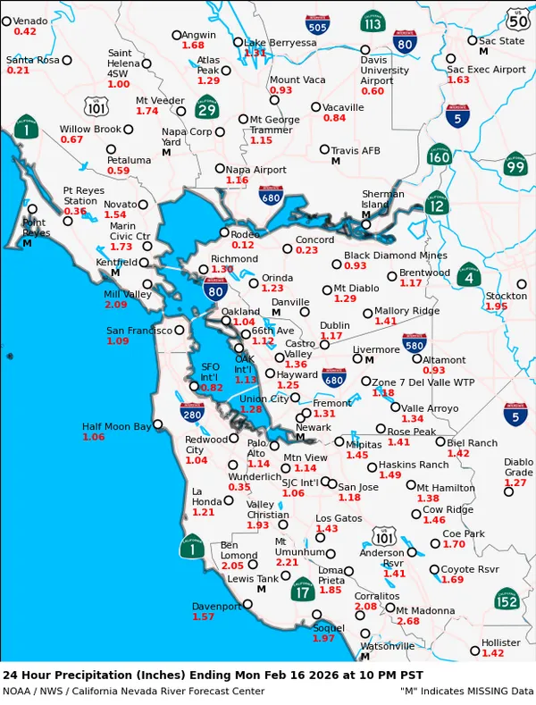
Rainfall varied sharply across the region as a storm system moved through
San Francisco Bay Area rain gauges recorded a wide spread in 24-hour precipitation totals during a recent storm, with measured amounts ranging from just over half an inch in parts of the inland East Bay to more than an inch near San Francisco International Airport.
Across the locations reported, the highest 24-hour total was 1.31 inches at San Francisco International Airport. San Francisco measured 0.84 inches over the same period. Nearby totals included 0.95 inches in Mill Valley and 0.71 inches in Petaluma, indicating heavier accumulation in some North Bay and coastal-influenced areas than in many interior valleys.
24-hour rain totals reported across selected Bay Area locations
- San Francisco International Airport: 1.31 inches
- Mill Valley: 0.95 inches
- Castro Valley: 0.92 inches
- San Francisco: 0.84 inches
- Dublin: 0.83 inches
- Fremont: 0.73 inches
- Petaluma: 0.71 inches
- Novato: 0.68 inches
- Palo Alto: 0.59 inches
- Milpitas: 0.59 inches
- Livermore: 0.51 inches
Why totals differ: terrain, storm track, and local exposure
Short-duration rainfall totals frequently vary across the Bay Area due to topography and wind-driven storm dynamics. Coastal hills and upslope-facing terrain can enhance rainfall, while leeward valleys may receive less in the same event. The 24-hour snapshot reflects that pattern, with higher totals around the central Bay and North Bay compared with portions of the inland East Bay.
Burn-scar runoff risk can rise even in moderate storms
Rainfall impacts are not determined by totals alone. In parts of Napa County, a flash flood warning was issued for areas near the Pickett burn scar, where fire-altered soils and steep slopes can accelerate runoff and increase the likelihood of debris flows. In burn-scar terrain, short bursts of heavier rain can present outsized hazards compared with surrounding areas.
Emergency warnings tied to burn scars typically emphasize the potential for rapid-onset flooding and debris movement, particularly in canyons, along small creeks, and near road cuts.
Looking beyond the 24-hour numbers
The reported totals represent one day of accumulation rather than a full accounting of multi-day storm impacts. When additional systems follow closely behind an initial round of rain, saturated ground can heighten the risk of localized flooding, slope instability, and hazardous travel conditions—even if subsequent storms bring lower daily totals.
For residents, the most relevant takeaways are the combination of rainfall intensity, where the rain falls relative to hills and burn scars, and how much water the ground has already absorbed from earlier storms.