High Surf Alerts and Overcast Skies: San Francisco's Saturday Outlook
Cloudy Skies and High Surf Warnings for San Francisco
San Francisco residents waking up this Saturday, February 7, 2026, can expect a predominantly grey and cool day as the high-pressure system that brought unseasonable warmth earlier in the week continues to recede. While the record-breaking 70-degree temperatures of the past few days have faded, the city remains in a transition period marked by heavy cloud cover and significant marine activity. Today’s weather will be characterized by overcast conditions and a persistent dampness that is typical for early February in the Bay Area.
Morning Forecast: A Chilly, Overcast Start
The morning hours will see a thick layer of clouds blanket the city from the Richmond District to the Embarcadero. Early risers will encounter a chilly start with temperatures hovering around 52°F. Humidity levels are expected to remain high, near 77%, which may result in some morning mist or light drizzle in higher elevations like Twin Peaks and Mount Davidson. If you are heading out for a morning coffee or a walk through Golden Gate Park, a light jacket and moisture-wicking layers are highly recommended.
Afternoon Outlook: Patchy Rain and Peak Temperatures
As we move into the afternoon, San Francisco is expected to reach a daytime high of approximately 61°F. While significant downpours are not in the immediate forecast, there is a 15% chance of patchy rain throughout the city between noon and 4:00 PM. The sky will remain mostly overcast, with only occasional breaks in the clouds. These conditions are driven by a weak low-pressure system approaching the coast, which is effectively pushing the warmer air inland and bringing in a cooler, more traditional marine layer.
Evening and Night: Clearing Conditions
Following sunset, the heavy cloud cover is expected to break slightly, transitioning to partly cloudy skies overnight. Temperatures will dip back down toward a low of 55°F. While the winds will remain relatively calm at an average of 5 to 6 knots, the damp air will maintain a bite, making it feel slightly cooler than the thermometer suggests. For those attending evening events downtown, the weather should remain dry enough for outdoor transit, though the dampness will persist.
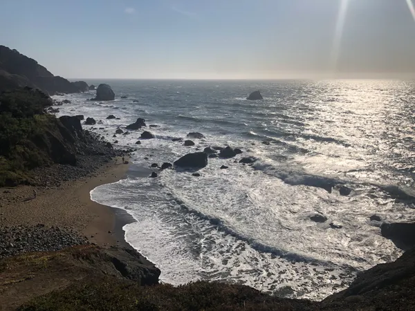
Critical Safety Alert: High Surf Advisory
The most significant weather feature for today is a High Surf Advisory issued by the National Weather Service, which remains in effect until 9:00 PM tonight. Forecasters are warning of dangerous coastal conditions that require immediate attention from residents and visitors alike:
- Extreme Wave Heights: Large breaking waves ranging from 17 to 22 feet are expected along the coast, particularly at west-facing beaches like Ocean Beach and Baker Beach.
- Sneaker Waves: There is a high risk of sneaker waves—sudden, large waves that can pull unsuspecting individuals into the sea from rocks, jetties, and shorelines without warning.
- Rip Currents: Strong rip currents are present, making swimming and surfing extremely hazardous.
- Coastal Erosion: Localized beach erosion is possible due to the intensity of the surf.
The National Weather Service advises staying off coastal rocks and jetties and keeping a safe distance from the water's edge. Never turn your back to the ocean today, as the surf conditions remain unpredictable and potentially life-threatening until the advisory expires late this evening.