Pilgrims inaugurate Camino de San Francisco, a two-day walk linking Mission San Rafael and Mission Dolores
A new Bay Area pilgrimage route begins with a small group on foot
A group of about 10 walkers set out February 21, 2026, on what organizers described as the inaugural trek of the Camino de San Francisco, a new Catholic pilgrimage route connecting Mission San Rafael Arcángel in Marin County with Mission San Francisco de Asís—better known as Mission Dolores—in San Francisco. The route is described as a 24.5-mile journey designed to be completed over two days.
The walk began with a short gathering at Mission San Rafael Arcángel before participants started south. The first day covered roughly 15 miles, ending near the north end of the Golden Gate Bridge. The group planned to continue on February 22 by crossing the bridge and finishing at Mission Dolores.
Route design, leadership, and participants
The inaugural group included students from Junípero Serra High School in San Mateo and adult leaders. The trek was led by Father Christopher Iwancio, who framed the walk as a combination of faith practice, community-building, and reflection. Participants interviewed during the event described motivations ranging from spiritual renewal to the desire for a shared experience and physical activity.
The Camino de San Francisco is positioned as a local counterpart to well-known pilgrimage traditions, with an emphasis on walking as a deliberate act of pause and focus. Organizers also linked the timing of the route’s launch to an anniversary observance associated with St. Francis of Assisi, the namesake of San Francisco.
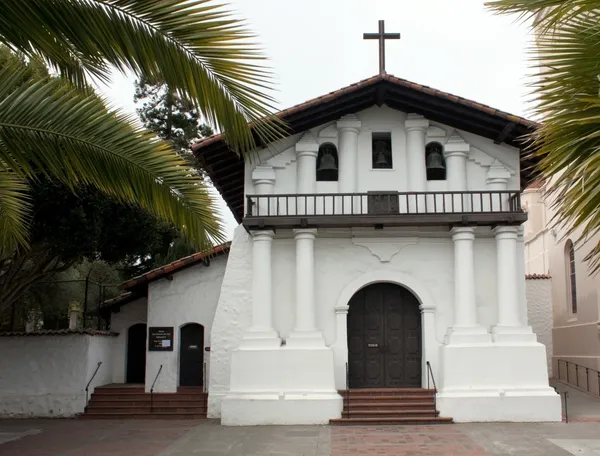
Historical setting: two missions, two eras
The route ties together two sites central to California’s mission period. Mission San Francisco de Asís was founded on October 9, 1776, and remains home to the Mission Dolores adobe chapel completed in 1791, widely recognized as the oldest intact structure in San Francisco. Mission San Rafael Arcángel was founded on December 14, 1817, originally established as a medical asistencia linked to the San Francisco mission and later elevated to full mission status in 1822.
By intentionally linking these locations, the Camino de San Francisco places contemporary walkers within an urban-and-suburban landscape shaped by layers of religious, civic, and transportation history, including the Golden Gate Bridge as a defining waypoint.
Public context and questions around mission-era remembrance
The launch arrives amid ongoing public debate in California about how institutions and communities should interpret and commemorate the mission era and figures associated with it, including Junípero Serra—canonized in 2015—whose legacy has been contested in civic spaces. In the Bay Area, recent disputes over monuments and public memorialization have underscored the sensitivity of historical commemoration.
Organizers of the new route have presented it as a pilgrimage focused on spiritual practice and encounter. As participation grows, observers will likely watch how the Camino de San Francisco defines its place within a region where history, faith, and public memory often intersect.
- Start: Mission San Rafael Arcángel (San Rafael)
- Finish: Mission Dolores (San Francisco)
- Distance: 24.5 miles (planned over two days)
- Key waypoint: Golden Gate Bridge crossing on day two
“Take a walk with somebody. Take a walk with your neighbors and meet people.”